The Hardest Thru Hike in the World
June 07, 2016
Words & Photos by Rich Rudow
Roots. Millions, and millions of roots. Within 100 yards of leaving the trailhead at the Highway 4 crossing of the Appalachian Trail (AT) outside of Rangeley, Maine, I realized that this backpacking trip was going to be far different than the hundreds of trips I had done in the southwest desert. For one, I had never hiked on a trail covered in slippery roots projecting randomly across and along the trail waiting to take down the unaware. The forest canopy supported by those roots was a magical jungle that blotted out the sun creating more humidity than I had ever experienced.
The “Green Tunnel,” the name attached to this section of the AT by thru hikers, was real! There was water everywhere, frequently flowing in the most minor drainages. The humid environment nurtured ferns, moss, and the most diverse mushroom population I had ever seen. Indeed, I immediately wondered if I was prepared for “this” hike. It was precisely the opposite of what I knew. Fortunately, I was backpacking with two friends who lived in the area; Mike St. Pierre, the Founder & CEO of Hyperlite Mountain Gear, and his girlfriend Helene Dicesare.
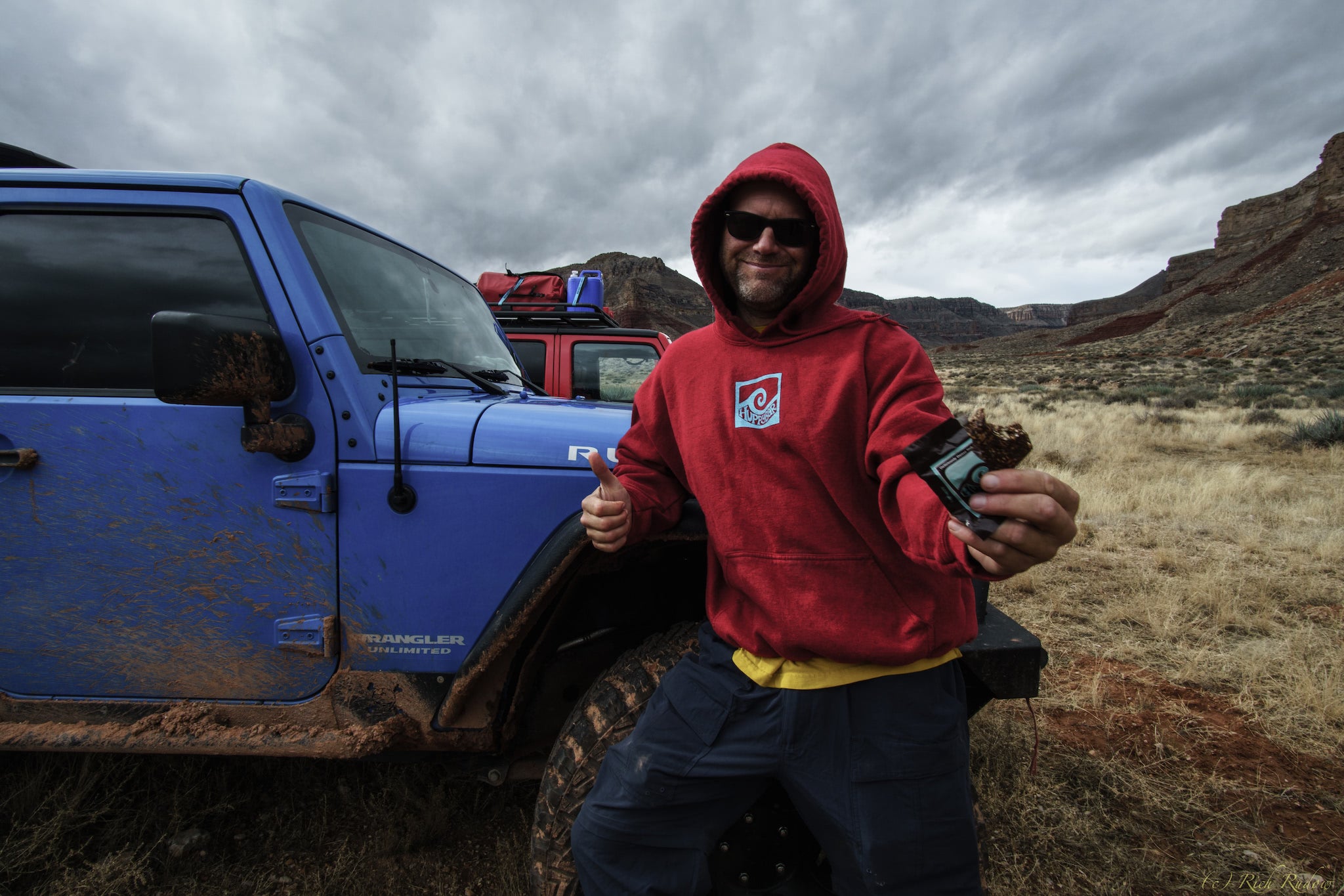
I live in Phoenix, and the Grand Canyon is in my backyard. I became enamored with it – one of the seven wonders of the world – after first visiting in 1989. Since that time, I’ve spent close to 1,000 days below the rim of Grand Canyon exploring the vast, remote trail-less areas. My passion includes exploring the Grand Canyon’s innumerable limestone slot canyons that lead to well over a hundred first descents in these narrow winding cathedrals using ropes and technical gear. Three years ago, I embarked one of the most challenging hikes in the World; a below-the-rim continuous traverse of the full length of the Grand Canyon.
The trip was entirely self-supported by pre-placing food caches below the rim along the 700-mile route. Two of us finished the hike in 57 days to become the ninth and tenth persons ever to complete this journey. As my friend Peter McBride, the renowned National Geographic photographer once quipped, “More people have walked on the moon.” Pete and his friend Kevin Fedarko completed a section traverse of Grand Canyon in thirteen months and wrote a terrific article about their experience pointing out that even something as vast and untamed as the Grand Canyon was being negatively impacted by the hand of man.
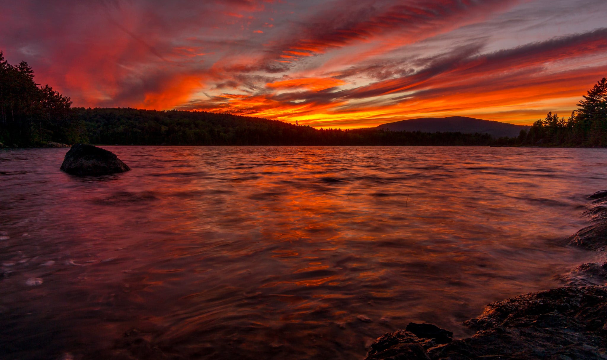
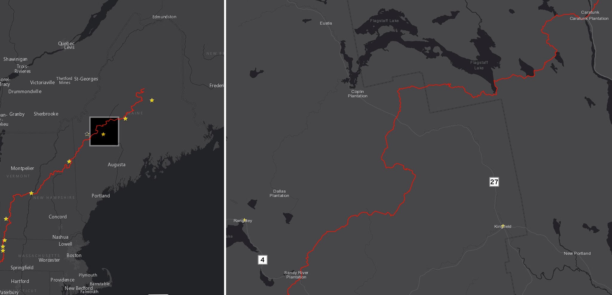
Mike had been cajoling me for a few years to come and experience the beauty of the Appalachian Trail in Maine. Our plan was to hike the AT from the Highway 4 junction near Rangeley to Caratunk in six and a half days for a total distance of about 70 miles. That AT section bounces up and down incredible ridgelines in Southern Maine starting with Saddleback Mountain and ending with a long traverse of Bigelow Mountain. The amazing green tunnel of the Maine forest filled with birch, poplar, maple, and pine trees would fill the gaps between the peaks above the tree line. This section of the AT is widely considered difficult, so we placed a food cache about halfway where the AT crosses Highway 27 to lighten our load.
Because of the proximity of road access, this trip could be broken into two sections for people who only have time for a long weekend either between Highway 4 and Highway 27 or between Highway 27 and Caratunk.
As a bonus, I learned that the AT has terrific hostels along the way to aid thru hikers.
We parked Mike’s truck at the Caratunk House Hikers Bed and Breakfast in Caratunk, the end of our route, and a B & B employee cheerfully gave us a shuttle ride to Rangeley where our hike began. As an aside, the Caratunk House is fantastic. They make great food, and they have a terrific resupply store for thru hikers. There is a different hostel operator near the Highway 27 junction providing the same hospitality and shuttle services for those people opting for the shorter section hike.

Like most people, I learned about the benefits of lightweight backpacking slowly and out of necessity. Over the years, I whittled my gear list down, taking only the essential things, and I gradually developed systems that included lightweight gear. Going down into the Grand Canyon was always optional. Climbing 5,000’ out was not. When it came time to walk the length of Grand Canyon, I reexamined my gear list again to shave even more weight.
My fundamental starting point is always my gear list, and it’s crucial to weigh every single item you’ll carry. If you don’t weigh everything to a fraction of an ounce, you can’t determine where you can logically reduce pack weight.
Naturally, I pulled one of my Grand Canyon gear lists off my computer and set about tweaking it for a week on the AT. I’ll admit right off the bat that I’ve never tried to be an “ultralight” guru. I need lightweight gear that I can use hard. Gear that won’t fail me. The consequences in the Grand Canyon are just too dire. I want to be on the leading edge with my gear choices, not the bleeding edge. And I want my gear to be comfortable.
Like most people, I love my experiences outdoors for the amazing sights and sounds that nature delivers. My enjoyment is badly impaired when I’m hurting with muscle aches and creaky knees while being forced to make miles just to make miles. On top of that, I love photography, and I’d like my pack base weight to be low enough to bring along some camera gear. After all, this is supposed to be fun. I wanted memories of Maine!
Here’s my planning process:
The first thing I did was look at the AT route from Rangeley to Caratunk. I used an online tool called Caltopo to plan my trip over a topographic map.
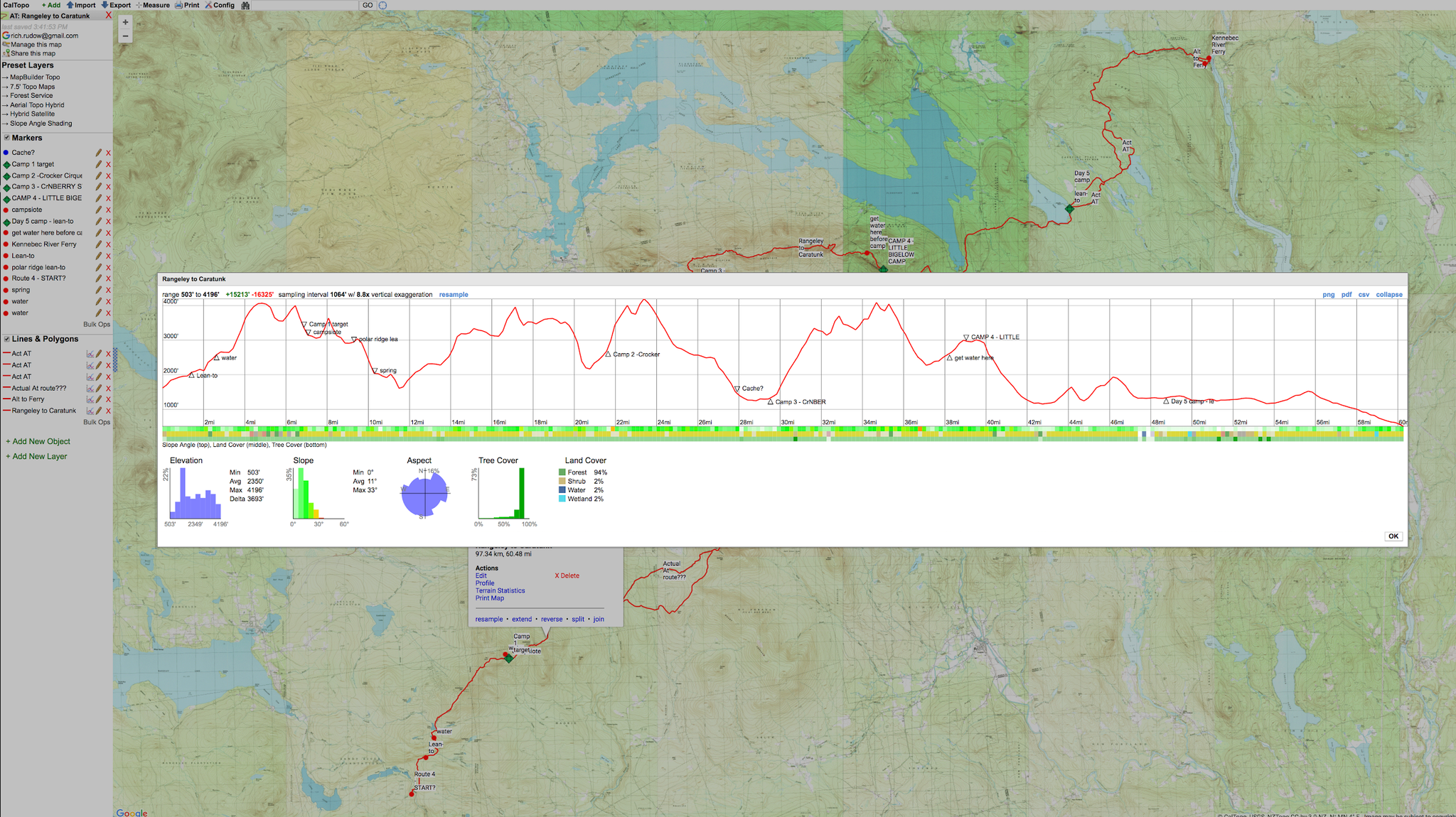
I noticed immediately that first 50 miles involved a lot of climbing and descents from roughly 1,200’ of elevation to about 4,200’. This would be “no walk in the park,” and going light would be necessary to make the trip far more enjoyable. I use my Galaxy S7 smartphone for GPS navigation on the trail, and there is an app called Guthook that provides maps and a lot of information about water sources and camp spots. The most interesting thing about Guthook is that app users can comment on their experiences. This proved invaluable. AT thru hikers would comment about campsites and water sources who had passed through just a few days earlier to add amazing new real-time knowledge to the app. All the thru hikers use it too. The app itself is free, but I had to buy the data for Maine for $8. Just get it. It was worth it for me.
I always check the weather forecast first before I decide what I’ll bring on a trip. That informs me about the shelter system, clothing layers, and sleeping bag to bring. It also helps to choose the right food. Miso soup is great for cold weather, but soups are less satisfying when it’s hot. I’ll often leave my shelter at home on short Grand Canyon trips where the forecast is good. That saves a lot of weight if you’re comfortable with “cowboy camping.” If rain is in the forecast, I’ll bring my incredibly light UltaMid Pyramid Tent.
I don’t usually use the floor insert since I don’t worry about bugs or other critters in the Grand Canyon. But what about Maine? Would the mosquitos fly me away? I didn’t know, so I decided to bring the UltaMid and the Half Insert. Despite the fact that the forecast low temperatures were in the 50’s, I still opted for my Western Mountaineering 30F sleeping bag, and my hooded Patagonia Nano Puff® jacket. I wasn’t sure how cool it might be if we opted to camp near the top of those 4,000’ peaks. I brought my Hyperlite Mountain Gear 4400 Southwest pack to allow ample space if I had to carry a bunch of water – a need quite common in the Grand Canyon. I didn’t realize that water was everywhere on this part of the AT, and often I carried less than a liter. Oh, the joy! I can find myself carrying two gallons in the Grand Canyon this time of year!
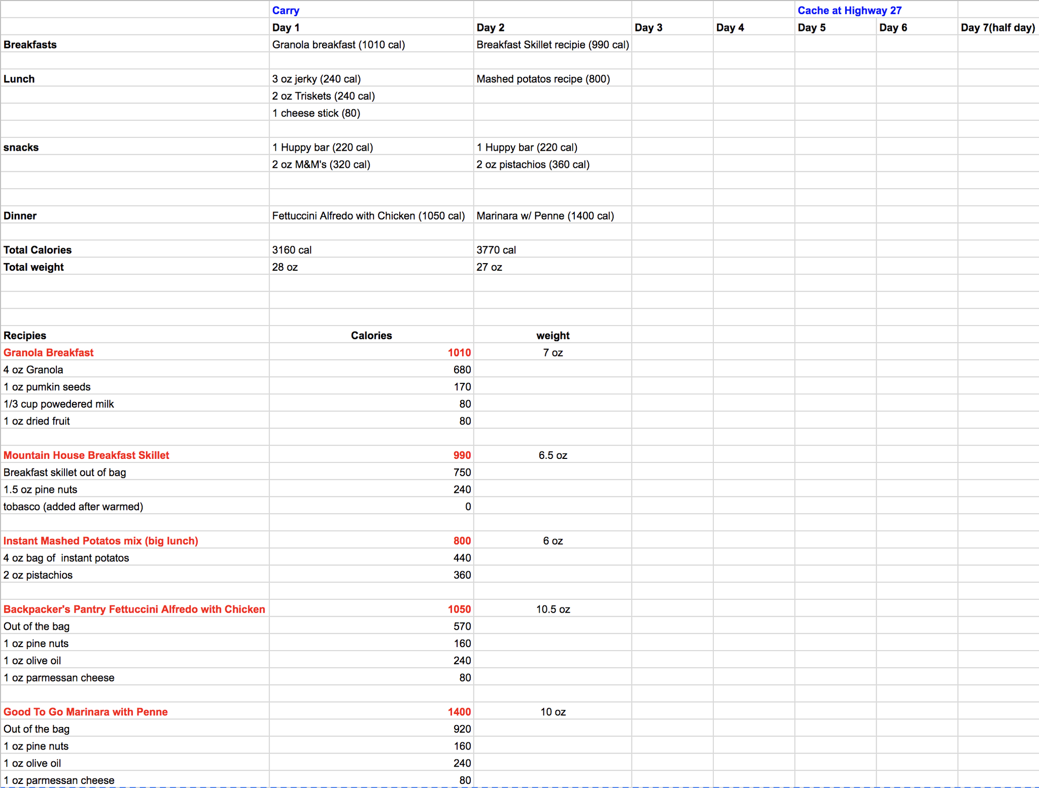
It’s easy to overshoot or undershoot your food needs on a trip like this. Beginners tend to overshoot which often results in a lot of extra weight to carry. Undershoot, and you’ll bonk on this elevation centric route and diminish the enjoyment. The elevation profile told me that I’d need to eat at least 3,000 calories per day, and probably more to not lose weight on this trip. Most people will burn 300 to 500 calories per hour on a route like this. Selection of healthy, calorie-rich food is a must. I could go on about this for pages and pages, but I’ll simplify things considerably here. You need 1,000 calories for breakfast, 1,000 calories for dinner, and another 1,000 calories in snacks and lunch.
This is easier to do if you start with prepackaged backpacking food, but modifications to these prepackaged foods are required. The foil packages holding freeze-dried foods are metallic and HEAVY so heat is held in when you add hot water to rehydrate the meal. Foil bags cause three problems. First, every foil pouch adds an ounce to your pack weight (that’s right – AN OUNCE per pouch). It’s easy to have an extra pound in your pack on a week-long trip in just foil bags alone. Second, foil packages have a lot of air in them and occupy more volume in your pack. On a longer trip it can be enough to force you to bring a larger pack adding even more weight. Third, I need more calories from my freeze-dried food than what is usually available in the standard foil package.
As a result, I open all freeze-dried packages and empty the contents into a quart sized freezer bag (weight ¼ ounce) discarding the original metallic packaging and desiccant bag. I then add an ounce of nuts to almost every meal. I like pine nuts in pasta meals and pistachios in potato-based meals. This adds roughly 200 calories per meal right off the bat. I’ll bring a bit of olive oil and Kraft parmesan cheese to add to pasta dinners, too. A half ounce of olive oil adds 120 calories! A little Tabasco goes a long way to add more flavor.
Many people fail to understand how essential fats are in endurance hikes. Fats are slowly converted to carbohydrates during endurance activities. Ideally, you want your backpacking diet to consist of (roughly) 40% fat, 35% proteins, and 25% carbohydrates. Nuts and olive oils are very healthy sources of fat and meaningful contributors to protein and carbohydrate needs.
Finally, you’ll want to carry a lightweight freezer bag cook system like the REpack to hold the heat in your food while it hydrates in the freezer bag. The REpack weighs less than an ounce and is also easy to hold in your hand while you eat. As a bonus, holding it is a great way warm your hands on a cold morning! Don’t forget your long-handled spoon. There is nothing messier than trying to eat out of the bottom of the bag with a short spoon. The Vargo titanium long-handled spoon is only half an ounce.
Your ideal target should be 120 calories per ounce of food you carry which equates to 25 ounces of food per day. If you’re like me, and sneak in a few luxury foods (chocolate, tequila, more cheese), that average might drop to 100 calories per ounce, but you should still be under 30 ounces of food per day.
Be sure to weigh your food! It’s the heaviest consumable item you’ll carry, and weight is the best way to know if you’ve calculated your food needs correctly.
Here’s my meal list for this hike for just the first few days. Note that I decided to ramp up the calories on day two for all of the climbs. It’s easy to get healthy calories if you repackage backpacking food and add some ingredients that you like. Finally, don’t forget to be sure your food has plenty of sodium and potassium to replenish what you sweat out. Bring some extra electrolytes to add to your water if you sweat a lot.
The fastest way to die in the Grand Canyon is to run out of water, and it’s very easy to do if you’re lost or unfamiliar with the location of scarce water sources.
One way to carry a lot of extra weight is to use conventional water bottles you buy in an outdoors store. They can weigh six ounces for a one-liter bottle. Instead, I carry one or two plastic Gatorade bottles (1.85 ounces each and very durable - they dent but don’t break) in the side pockets of my pack, and one or two Platypus collapsible bladders (1 ounce each) for overflow when hauling a lot of water between distant sources. To treat water, I usually carry Aqua Mira, a chemical treatment that is very effective and weighs three ounces. Unfortunately, it takes five minutes for the chemical to activate with an additional wait of 15 to 30 minutes before you can drink.
Pump water filters that you find in most outdoor stores are quite heavy (often a pound or more) and they clog fairly quickly requiring the added weight of cleaning kits or back flushing tools. The Sawyer Squeeze Filter is a good lightweight alternative (also three ounces) to chemical treatments, but only if the water sources are clean. They clog fast and require a lot of back flushing with silty water.
I brought Aqua Mira on this hike being unsure about the quality of water on this section of the AT. However, the water was quite good, and a Sawyer squeeze filter would have worked just fine. The main advantage of the Sawyer squeeze filter is that you can drink right away after filtration.
One final note: The idea that water is clean enough to drink without treatment is a fallacy. I’ve had giardia from the clearest looking water. I’ve seen the purest streams with dead bighorn sheep 100 yards up the creek, too. Treat your water every single time without fail.
One of the benefits of backpacking with friends is pawning some weight off on them. You can share a shelter or cooking system, for example. One person carries the stove. Another carries the fuel. This can reduce the total weight you’re carrying and allows broader choices. One person carries the tent, and another carries the floor insert or poles. I tend to favor a Jetboil cooking system on longer hikes with friends because it’s far more fuel efficient than lighter weight alternatives.
This fuel efficiency can actually make the Jetboil solution lighter on longer trips than other ultralight alternatives, like some uber light alcohol stoves. Especially when you have a group and can divide the weight. And the Jetboil is so fast and convenient! On this trip, I carried the Jetboil and Mike carried the fuel. If you’re solo, you need to carry everything and an MSR pocket rocket or alcohol stove with a titanium pot could be significantly lighter if you can resupply every three or four days.
Caching food is another way to keep your weight down, and the Rangeley to Caratunk section of the AT is PERFECT for it. Highway 27 bisects the AT about midway. We cached the second half of our food and some stove fuel. Mike’s birthday happened to be on the day we hit the cache and Helene had a piece of cake and candle cached away waiting for the occasion. You can even cache fresh clothes. Another benefit of a cache is you can leave your trash (and dead fuel canisters) behind. I brought a few too many camera gadgets that I wasn’t using so I also left those behind before tackling Bigelow Mountain.
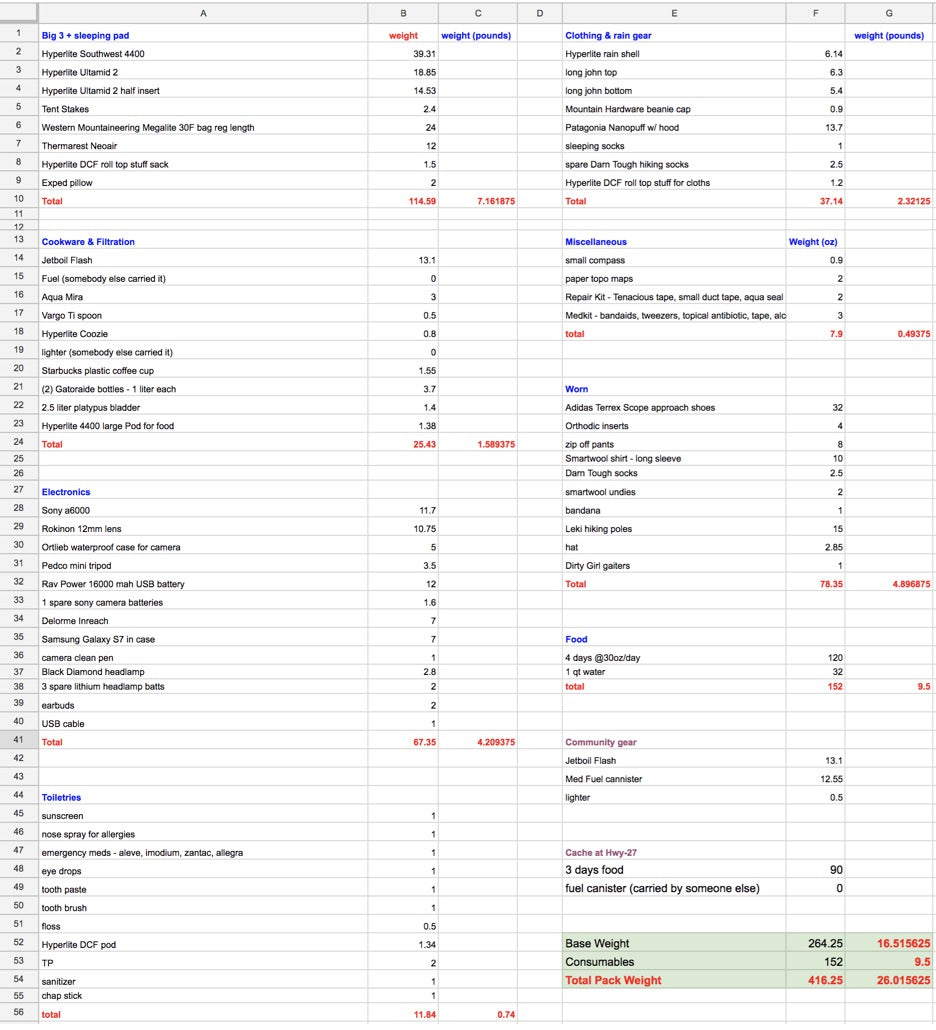
My pack weighed just over 26 pounds at the start with four days of food and a liter of water on board. I was unsure how much water to carry, but we passed small streams often which gave me the confidence to carry only a liter or two at a time. Better yet, this included my camera gear and extra batteries. If I had been content with my smartphone camera I could have eliminated three pounds.
I’ll also note that I needlessly brought my larger pack and I would have been fine with my Hyperlite Southwest 3400 for a potential savings of seven ounces.
I would have done fine too with my lighter sleeping bag. I have a Western Mountaineering Highlite that is good down to 35F and weights only 16 ounces. I could have saved half a pound right there.
While I usually don’t use an enclosed tent, I was thankful to have the UltaMid 2 half insert to keep a few mosquitos at bay. Helene woke up one morning, and a slimy slug had moved into her shoe. Eew!!! Things I don’t worry about while cowboy camping in the Grand Canyon!
YOUR CART IS EMPTY
Let’s find you the right gear for
your next adventure.